Carlos E. Del Castillo at NASA Goddard Space Flight Center reflects on the PACE mission, and how Artificial Intelligence can help better understand our intricate living planet.
Our planet operates like a super organism, where the interactions among oceans, atmosphere, land, and cryosphere shape our environment.
To comprehend this intricate system, Earth System Science emerged as a discipline that integrates remote sensing, field and laboratory investigations, and modeling. This holistic approach aims to unravel the workings of the Earth System and its responses to human activities.
The advent of satellite-based measurements was crucial in advancing our understanding of the planet. Seasat, launched in 1978, was the first ocean satellite observatory and a valiant proof of concept that lasted a few months. Nowadays we expect our orbital observatories to last over a decade, and the complexity and volume of the data and the value of the information continues to increase. Satellite data are crucial in addressing science and policy questions and in providing information used by the government, private sector, and environmental and national security concerns.
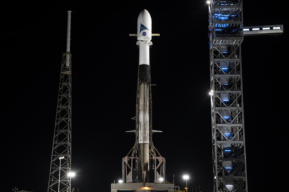
On February 8, 2024, NASA significantly advanced the state-of-the-art by launching the Plankton, Aerosol, Cloud, ocean Ecosystem (PACE) mission.
All previous missions focused on ocean biogeochemistry measured the color of the ocean at a handful of wavelengths (6 to12). In contrast, the PACE mission measures over 100 wavelengths (colors) from the ultraviolet to the near infrared and is therefore referred to as a ‘hyperspectral’ instrument. The color of the ocean gives us important information about what is inside those waters. One of these water constituents we are particularly interested in is called ‘phytoplankton’. While microscopic, these plants are not only responsible for over 50% of the oxygen the readers are breathing right now but can also serve different functions depending on the type of phytoplankton present at a location. Some of them can be toxic to other animals including humans, while others feed larger organisms including many that we rely on for food. Ocean color also allows us to measure many other important components like organic matter and particles. The increase in information from PACE will allow us to improve legacy measurements from earlier missions but will also surpass them by helping determine the type of phytoplankton present in our ocean. This significant advancement in capabilities is key because, like land plants, different marine plants have specific roles in the ecosystem and respond differently to environmental change. The capabilities of PACE are needed to monitor, understand, and predict future changes.
The PACE mission also has two polarimeters designed to measure various aspects of our atmosphere, including clouds and aerosols.
This information will be critical for assessing air quality, various weather events such as dust storms and volcanic eruptions as well as reduce our uncertainties of the contributions of clouds and aerosols to the Earth heat forcing. PACE will also gather data across land areas, positioning it as a comprehensive Earth System Science mission. It not only captures measurements of oceans, atmosphere, and land but is specifically designed to study the interactions among these elements. Finally, the PACE mission also tackled the thorny problem of “research to operations” by implementing the Early Adopters Program, where data users in the operational community were included in some aspects of mission planning, and provided access to simulated data, so they could be ready to exploit the data right after launch. This step helps scientific advancements to contribute effectively to solving practical problems, improving processes, or enhancing decision-making in various fields, including science, technology, industry, and public policy.
One of the outcomes of the technological development that has enabled missions such as PACE is that the amount of data available becomes larger and more complex. As a result, expanding the current data distribution capabilities and accessibility of the data becomes increasingly critical. Data access and transparency are imperative in maintaining trust in the scientific process and in the development of science-informed policies. NASA has a long history in the public distribution of satellite data. By principle and regulations, everyone has unrestricted access to our research data. In the case of ocean color data, we were ready to distribute data one year before launch through a well-known, web-based outlet. This has been the case since the 1980’s. This longstanding practice, now formalized as “open data open science,” is essential for expediting scientific breakthroughs and for informing and educating the public.
The complexity and volume of the new data, and the need to combine multiple data sources, requires the use of new analytical methods including various flavors of machine learning and artificial intelligence (ML-AI). Ocean scientists have been using ML for decades in various applications, including the analysis of satellite data. We are now, however, facing a new paradigm that will accelerate its use. Data availability has increased, and the need for ML-AI has grown significantly while becoming more accessible. Therefore, technical data and ML-AI are now inevitably intertwined. This creates practical and ethical questions for scientists and policy makers. The fact that a tool is readily available and seemingly easy to use does not mean that everyone could use it well, and ML-AI is not the exception. The same goes for easily accessible research data. Regardless of the tools used, it is important to bear in mind that: 1- Computers are fast and efficient, but they are not truly intelligent, ethical, or moral; and 2- scientists and policy makers are ultimately responsible for scientific results and their use in shaping policy. Scientists have the responsibility of piercing the black box of ML-AI methods to understand how ML-AI are trained and how the data are being analyzed. Policy makers should continue to encourage open science open data policies, transparency in ML-AI use, and be clear-eyed about its benefits and shortfalls. This necessitates close collaborations between scientists, data scientists, applied mathematicians, statisticians, and computer scientists. Formal interactions between policy makers and scientists should be broader and more frequent. The era where all science was done by the lone specialist with a few graduate students is over. As multidisciplinary approaches become necessary and the exploitation of large data sets by ML-AI becomes the norm, government agencies and academic departments need to quickly evolve to adapt to this new paradigm.
What is next in ocean measurements?
We cannot fully understand the oceans without looking at the rest of the components of our planet. But there are specific ocean measurements that need improvement. We can measure well properties in the surface of the ocean using satellites. The next technological step is to measure the vertical dimension of the ocean from space. This will include depth profiles of plankton, particles, temperature, and salinity in the ocean. These measurements are needed fast if we are going to keep up with monitoring and understanding our fast-changing planet. These scientific requirements can be addressed with Lidar technologies, particularly when combined with polarimetry and hyperspectral measurements of ocean color. Happily, these same technologies also work in measuring many important atmospheric parameters. These applications of Lidar are a scientific and engineering challenge, but one that can be addressed. Other challenges might be more vexing. In the field of Earth Remote Sensing, the mission development process is slow, but expensive. The PACE mission took over 20 years to move from the research concept to the launch pad. It took a decade to build the instruments and space craft. For perspective, the Manhattan project, infinitely more complex than PACE, took about 4 years. The slow cadence in satellite missions is often caused by risk-averse processes and budgetary uncertainties. Not only are we not developing new technologies and getting all the scientific information we could get, but slow mission cadence inevitably results in diffusion of institutional memory and technical knowledge as well as increased cost. Agencies should review their risks postures and streamline processes. Appropriators should provide a more stable funding environment, understanding that funding uncertainties increase costs.
We have new, fantastic data sets and the analytical tools. We also have a clear vision of what new measurements and research work are needed. We just need to accelerate the speed of space missions’ development. They are crucial to better understand our intricate living planet.
By Dr. Carlos E. Del Castillo, Chief of the Ocean Ecology Laboratory, NASA Goddard Space Flight Center.
Dr. Carlos E. Del Castillo is the Chief of the Ocean Ecology Laboratory at NASA Goddard Space Flight Center. He was previously a member of the Senior Professional Staff with the Space Department of the Johns Hopkins University Applied Physics Laboratory and an Associate Research Professor at the Johns Hopkins University Department of Earth and Planetary Sciences.
 Regional Headquarters